Fact statements
October 4, 2026Report of the National Bureau
Report of the National Bureau for Defending Land and Resisting Settlements
Report of the National Bureau for Defending Land and Resisting Settlements
The Occupation Approves a Package of Projects Covering 18 New Settlement Jurisdiction Areas in the West Bank, Aimed at Fragmenting Its Territorial Contiguity and Urban Areas, Tightening the Encirclement of Palestinian Villages and Towns, and Turning Them into Separate Enclaves
3 October 2026
Accelerating settlement plans are aimed at fragmenting the territorial contiguity of the West Bank and its urban areas through the expansion of settlements and settlement outposts, the construction of roads and alteration of traffic routes, and the seizure of land. These measures further deepen the isolation of Palestinian communities and restrict the movement of Palestinian residents.
The settlement plans receive support and protection from the Israeli army. Settlers have placed the fragmentation of the Ramallah–Al-Bireh urban area on their agenda through the reorganization of roads and traffic routes in the area, including opening Road 463 to settler traffic. This forms part of a plan that would separate eight villages and two large neighborhoods in the northern Ramallah–Al-Bireh area from areas to their south. The plan would involve the establishment of new military posts and checkpoints, the placement of concrete barriers, and the relocation of military bases. This would obstruct Palestinians’ daily movement and could also impede access to vital institutions, including the Istishari Arab Hospital, the Arab American University, and infrastructure facilities such as the wastewater treatment plant.
At the busy Surda junction, where Road 463 intersects with the road coming from Birzeit, six Israelis were seen on 9 September erecting a sign in Hebrew. Photographs taken at the site showed members of the family of Ita and Efraim Tzur, a mother and son from the Beit El settlement who were killed at the location in December 1996, naming the site “Tzur Junction.”
The following week, settlers arriving by car from the direction of the Dolev settlement spread out along what is known as the “Chinese Road,” hanging Israeli flags at two roundabouts and along both sides of the road. The Israeli army opened an iron gate for them, above which is a military post overlooking and controlling the area. In a video documenting the hanging of the flags, the settlers wrote: “Here we are returning the route to Jewish hands.”
According to a report published by the Israeli newspaper Haaretz on 28 September, an intensive campaign is underway to open a transverse road running through the Ramallah urban area to settler traffic. This is taking place alongside other measures to take control of land and roads along what is known as the “Fallerstein Axis.” According to the report, these developments demonstrate settlers’ capacity to plan initiatives that could be replicated in other Palestinian areas.
According to Haaretz’s assessment, opening the road to settler traffic would require additional security measures, including the establishment of military posts and checkpoints and potentially the seizure of adjacent land. This could separate the villages of Ras Karkar, Al-Janiya, Deir Ammar, Beitillu, Jamala, Deir Nidham, and Kafr Ni’ma, as well as two large neighborhoods in the northern Ramallah urban area—Al-Reihan suburb and Al-Tireh neighborhood, or the neighborhoods surrounding the Chinese Road and Istishari Arab Hospital north of Ramallah—from the areas located south of the road.
The report concludes that the Israeli army’s response to settlers’ demands to shorten their travel routes, combined with the proliferation and legalization of settlement outposts and the expansion of the road network serving settlements, would further fragment Palestinian space into smaller and increasingly disconnected areas, making movement between them longer and more difficult.
The right-wing religious weekly Olam Katan, associated with the Religious Zionism movement, reported that the Israeli army is working to create the conditions necessary to open this road to settler traffic. The road passes through the heart of the Ramallah–Al-Bireh urban area and could separate neighborhoods and villages in the north of the urban area from the remainder of the area.
The newspaper quoted Yisrael Gantz, Chairman of the Yesha Council and head of the Binyamin Regional Council in the central West Bank, as saying that a preliminary decision to open the road had already been made, that funding was available, and that the Israeli army had begun security and legal preparations for its implementation.
The plan to reopen the road is closely connected to settlement outposts surrounding the Talmon and Dolev settlement bloc, west and northwest of Ramallah. Several pastoral and agricultural outposts have been established in the area surrounding the two settlements. According to the report, these outposts have gradually taken control of extensive areas of olive groves and water springs belonging to nearby Palestinian villages, and their settlers are now demanding freedom of movement along this route.
The report also refers to a new outpost adjacent to Al-Tireh neighborhood, where intensive settlement activity has recently been observed on a plot of land situated along a longitudinal road branching off Road 463 and extending southward toward Al-Tireh. Settlers and the army have leveled the land, installed concrete blocks and a closed gray iron gate, raised Israeli flags over it, and used the site as a gathering place and for prayers.
Southern West Bank
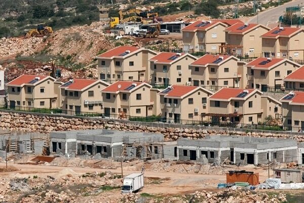
In the southern West Bank, Israeli authorities are planning to establish a new settlement south of the Gush Etzion settlement bloc, named “Gad Natan.” The move forms part of plans aimed at establishing geographic settlement contiguity extending toward Hebron, Jerusalem, and the Dead Sea.
The settlement is located along the road connecting Gush Etzion, Hebron, and the Kiryat Arba settlement, with the stated objective in the report of expanding Israeli control and strengthening the settler presence in the southern West Bank. The Gush Etzion Regional Council and its community center designated Tuesday, 29 September 2026, for an official inauguration ceremony at the site, including guided tours for settlers led by council head Yaron Rosenthal.
Israeli sources cited in the report indicate that the Gush Etzion Regional Council experienced a 5.1% increase in its settler population during the past year, considerably higher than the average population growth rate within Israel.
The Israeli government had also recently approved the establishment of six new settlements—through the legalization of existing outposts and their conversion into independent settlements—within the Gush Etzion settlement bloc.
The six settlements recently approved and legalized in the Gush Etzion bloc include:
- Masuot Har, established at a location classified by Israeli authorities as an archaeological and historical site, formerly Masuot Yitzhak;
- Givat Adulam, intended to connect the Gush Etzion bloc westward toward the Elah Valley and Beit Shemesh area;
- Bnei Kedem, an outpost in the eastern countryside of Bethlehem Governorate that has been formally legalized and expanded;
- Yatziv/Avia, east of Beit Sahour, for which a master plan has recently been approved and prepared to establish it as an independent settlement;
- Ya’ar HaKeren, a forest outpost included in the government’s legalization and regularization decision to expand control over the surrounding area;
- Sde Bar, an agricultural outpost near the Nokdim settlement east of Bethlehem, which has been incorporated and converted into a government-recognized settlement within the expanded planning framework of Gush Etzion.
The report states that this accelerating settlement expansion in the Gush Etzion bloc has severe and direct consequences for Palestinian communities in the Bethlehem and Hebron governorates, tightening the encirclement of Palestinian villages and towns and turning them into separate enclaves.
The principal effects can be summarized as the fragmentation of geographic contiguity and the isolation of cities and villages, including the separation of Bethlehem from Hebron. The establishment of settlements such as Gad Natan and Ma’ale Rehav’am in the southern part of the bloc disrupts the natural and historical Palestinian geographic connection between Bethlehem and Hebron.
It also transforms villages into enclaves. Villages including Al-Walaja, Battir, Nahhalin, Wadi Fukin, and Jab’a are described as being surrounded by settlements, restricting their natural urban expansion.
Also in the southern West Bank, Israeli authorities approved advancing two settlement plans comprising 567 housing units in Hebron Governorate, as part of the accelerated settlement planning and expansion taking place in the West Bank during the current year.
The approval covers 342 units in the Asa’el settlement, established on land belonging to the town of As-Samu’, under Plan No. 525. The Israeli cabinet approved its conversion into a settlement in 2023.
A further 225 units are planned for the Beit Hagai settlement, established on land belonging to Al-Rihiya in the town of Dura, under Plan No. 517/4. Israeli authorities had previously advanced both plans through earlier planning stages before they were moved, at a session of the so-called “Planning Council” on the 23rd of the month, to the validation stage, rendering the plans effective and allowing implementation and construction procedures to proceed.
Northern West Bank
According to the report, settlement activities and plans have also extended to the northern West Bank. Last week, Israeli authorities issued a new tender for the construction of 400 housing units in the Karnei Shomron settlement, east of Qalqilya Governorate, as part of several construction projects aimed at expanding the existing settlement and increasing its residential capacity.
The tender sets 23 November 2026 as the deadline for submitting bids. According to the report, this effectively moves the project from the planning and authorization phase toward marketing and construction.
The report considers the expansion particularly significant because of Karnei Shomron’s strategic location in the northwestern West Bank and its impact on extensive areas of land belonging to Azzun, Jinsafut, and Kafr Laqif. It argues that the expansion further fragments Palestinian communities in the area.
The continuing expansion of the settlement is intended to integrate it with surrounding settlements such as Kedumim, Ma’ale Shomron, and Immanuel, creating a large settlement bloc—or settlement city—linking the interior of the West Bank with areas inside the 1948 boundaries.
According to the report, the project would isolate Palestinian villages and towns east of Qalqilya, including Azzun, Jinsafut, and Kafr Laqif, turning them into surrounded enclaves, restricting their natural urban expansion, and geographically separating them from Qalqilya and Nablus.
It would also reinforce Israeli control along Road 55, the principal transportation artery in the area, which the report says would result in additional checkpoints and restrictions on Palestinian movement.
The expansion is not limited to residential construction. It is accompanied by the construction of roads, the fencing-off of additional areas, and the seizure of hundreds of dunams of fertile agricultural land and olive groves that constitute a major source of livelihood for local residents.
Alongside the tender for 400 units in Karnei Shomron, Israeli authorities have approved several other plans in Qalqilya Governorate. These include a plan involving land belonging to Jayyus and Immatin in September 2026, following the issuance of a military order for the seizure of 160 dunams of land belonging to Jayyus, located behind the Separation Wall, in addition to 21 dunams belonging to the village of Immatin east of the governorate.
The report states that Israeli authorities approved a package of projects encompassing 18 new settlement jurisdiction areas in the West Bank. Qalqilya Governorate received a substantial share of these projects through the expansion of pastoral and agricultural outposts in the eastern part of the governorate—including those extending between Jinsafut, Jit, and Hajjah—and their conversion into independent settlements or neighborhoods affiliated with larger settlements.
End of report.